
Page 435 - FY 2025 Adopted Operating Budget and Business Plan
P. 435
Return to Table of Contents
Leverage Technology
Goal 1: Ensure Availability of Information, Programs, and City Services
Objective 2: Implement New Technology
Project Performance Measure(s) Department(s)
LT Traffic Management • Implementation: Installing Devices at Public Works
1.2.3 Technology Improvements Locations and Bringing them Online. Use
Crowdsourced Data and GIS database for
Travel Time Data Collection and Evaluation
• Management: Using Device Data to
Improve Traffic Flow
Summary:
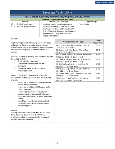
Actual
Corridor Travel Time Goals
Implementing smart traffic management technology Travel Time
will assist the City in developing a more efficient NB Cooper St. (Turner-Warnell Rd. to I-30) 21:58
transportation system that enhances regional mobility 23:21 (+/- 2 min 20 sec)
and increases the quality of life for residents and SB Cooper St. (I-30 to Turner-Warnell Rd.) 22:40
visitors. 22:07 (+/- 2 min 13 sec)
NB Collins St. (Mansfield Webb Rd. to Mosier 25:46
Some of the benefits resulting from implementing new Valley Rd.) 28:31 (+/- 2 min 51 sec)
technology include: SB Collins St. (Mosier Valley Rd. to Mansfield 27:59
• Reduced traffic congestion Webb Rd.) 26:16 (+/- 2 min 38 sec)
• Prioritized traffic based on real-time EB Division St. (West City Limit to East City 17:41
conditions Limit) 15:57 (+/- 1 min 36 sec)
• Quicker response to traffic incidents WB Division St. (East City Limit to West City 15:46
• Reduced pollution Limit) 15:46 (+/- 1 min 35 sec)
EB Pioneer Pkwy. (West City Limit to East City 17:46
During FY 2025, work to implement new traffic Limit) 17:12 (+/- 1 min 43 sec)
management technology will focus on the following WB Pioneer Pkwy (East City Limit to West 17:28
projects: City Limit) 16:16 (+/- 1 min 38 sec)
• Installation of additional connected vehicle
devices on major corridors
• Installation of additional CCTV cameras for
traffic monitoring
• Increasing the number of intersections
evaluated by the Automated Traffic Signal
Performance Measures (ATSPMs) monitoring
system.
• Use of Waze crowdsourced data and GIS
database to analyze travel time data and
detect congestion.
Update:
The Department is coordinating with North Central
Texas Council of Governments (NCTCOG) for
implementing long term strategies for connected
vehicles and travel efficiency.
62