
Page 512 - FY 2025 Adopted Operating Budget and Business Plan
P. 512
Return to Table of Contents
Public Safety
Goal 1: Utilize Targeted Initiatives and Industry Best Practices and Policies to Foster a Safe
Environment
Objective 2: Protect Public Well-being
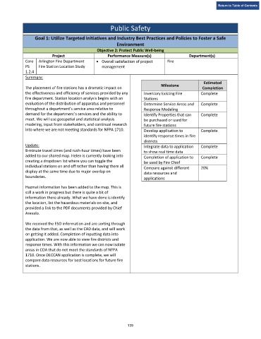
Project Performance Measure(s) Department(s)
Core Arlington Fire Department • Overall satisfaction of project Fire
PS Fire Station Location Study management
1.2.4
Summary:
Estimated
Milestone
The placement of fire stations has a dramatic impact on Completion
the effectiveness and efficiency of services provided by any Inventory Existing Fire Complete
fire department. Station location analysis begins with an Stations
evaluation of the distribution of apparatus and personnel Determine Service Areas and Complete
throughout a department’s service area relative to Response Modeling
demand for the department’s services and the ability to Identify Properties that can Complete
meet. We will use geospatial and statistical analysis be purchased or used for
modeling, input from stakeholders, and continual research future fire stations
into where we are not meeting standards for NFPA 1710. Develop application to Complete
identify response times in fire
districts
Update: Integrate data to application Complete
8-minute travel times (and rush-hour times) have been to show real time data
added to our shared map. Helen is currently looking into Completion of application to Complete
creating a dropdown list where you can toggle the be used by Fire Chief
individual stations on and off rather than having them all
Compare against different 20%
display at the same time due to major overlap on data resources and
boundaries. applications
Hazmat information has been added to the map. This is
still a work in progress but there is quite a bit of
information there already. What we have done is identify
the location, list the hazardous materials on-site, and
provided a link to the PDF documents provided by Chief
Arevalo.
We received the ESO information and are sorting through
the data from that, as well as the CAD data, and will work
on getting it added. Completion of inputting data into
application. We are now able to view fire districts and
response times. With this information we can now isolate
areas in COA that do not meet the standards of NFPA
1710. Once DECCAN application is complete, we will
compare data resources for best locations for future fire
stations.
139