
Page 406 - NRH FY20 Approved Budget
P. 406
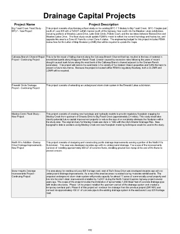
Drainage Capital Projects


           Project Name                                      Project Description
         Big Fossil Creek Flood Study -   This project consists of performing a flood study on the existing BFC-7 Tributary to Big Fossil Creek.  BFC-7 begins just
         BFC7 - New Project     south of Loop 820 with a TxDOT outfall channel south of the highway, then south into the Meadow Lakes subdivision,
                                including portions of Meadow Lakes Drive, Lake Side Circle, Pebble Court, and the two lakes between Riviera Drive and
                                Meadow Lakes Drive.  The flood study would update FEMA's model to reflect the current hydrology and hydraulics, and
                                upgrade this area to a Zone AE from its current Zone A status.  The engineering budget for this project includes FEMA
                                review fees for the Letter of Map Revision (LOMR) that will be required to update the maps.


         Calloway Branch Channel Repair   This is for the repair of failing channel along the Calloway Branch Channel that has resulted in the loss of material in
         Project - Continuing Project  several backyards along Waggoner Ranch Road. Erosion caused by excessive rains following the years of recent
                                drought caused bank failure along the west bank of the Calloway Branch channel adjacent to the Graham Ranch
                                subdivision.  This project will restore the west bank in the vicinity of the Graham Ranch properties and fortify the bank to
                                prevent a future recurrence.  Because the project is located within FEMA's regulatory floodway, both a CLOMR and
                                LOMR will be required.


         Emerald Circle Drainage   This project consists of extending an underground storm drain system in the Emerald Lakes subdivision.
         Project - Continuing Project


         Mackey Creek Flood Study -   This project consists of creating new hydrologic and hydraulic models to provide regulatory floodplain mapping for
         New Project            Mackey Creek from upstream of Shauna Drive to Big Fossil Creek (approximately 2.4 miles). This study would also
                                identify potential future capital improvement projects to reduce the size of or completely eliminate the floodplain within
                                the study area. The original study for Mackey Creek was done in 1985 with the City's Master Drainage Plan.  New
                                topographic data is available along Mackey Creek and new floodplain modeling techniques would be used in the study.


         North Hills Addition - Bewley   This project consists of designing and constructing public drainage improvements serving a portion of the North Hills
         Drive Drainage Improvements -   Subdivision.  This area was developed decades ago with no underground drainage. The scope of the improvements
         New Project            consists of installing approximately 450 LF of concrete flume, installing grouted rock riprap at the end of the flume to
                                prevent erosion.


         Snow Heights Drainage   The area along the eastbound Loop 820 frontage road, east of Rufe Snow Drive was developed decades ago with no
         Improvements Project -   underground drainage improvements. As a result the area becomes inundated during moderate rainfall events. The
         Continuing Project     proposed underground storm drain system will provide capacity for almost 11 acres of commercially zoned property and
                                ties into the storm drain improvements installed by TxDOT during the North Tarrant Express highway project several
                                years ago. The scope of the project includes the installation of aproximately 1,200 linear feet of concrete drainage pipe
                                with intake structures.  Phase I of the project installed the upstream portion of the drainage system and created a
                                temporary overland path. Phase II of this project will continue the drainage from the previous project (DR1801) and
                                connect via approximately 450 LF of concrete pipe to the existing drainage system in the eastbound Loop 820 frontage
                                road.


                                                             402