
Page 310 - NRH FY20 Approved Budget
P. 310
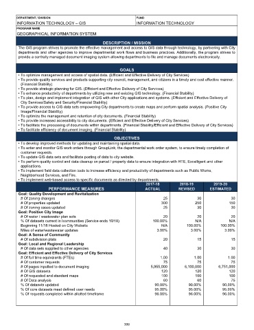
DEPARTMENT / DIVISION                                     FUND
         INFORMATION TECHNOLOGY – GIS                              INFORMATION TECHNOLOGY
         PROGRAM NAME
         GEOGRAPHICAL INFORMATION SYSTEM
                                                   DESCRIPTION / MISSION
          The GIS program strives to promote the effective management and access to GIS data through technology, by partnering with City
          departments and other agencies to improve departmental work flows and business practices. Additionally, the program strives to
          provide a centrally managed document imaging system allowing departments to file and manage documents electronically.


                                                           GOALS
          • To optimize management and access of spatial data. (Efficient and Effective Delivery of City Services)
          • To provide quality services and products supporting city council, management, and citizens in a timely and cost effective manner.
           (Financial Stability)
          • To provide strategic planning for GIS. (Efficient and Effective Delivery of City Services)
          • To enhance productivity of departments by utilizing new and existing GIS technology. (Financial Stability)
          • To plan, design and implement integration of GIS with other City applications and systems. (Efficient and Effective Delivery of
           City Services/Safety and Security/Financial Stability)
          • To provide access to GIS data sets empowering City departments to create maps and perform spatial analysis. (Positive City
           Image/Financial Stability)
          • To optimize the management and retention of city documents. (Financial Stability)
          • To provide increased accessibility to city documents. (Efficient and Effective Delivery of City Services)
          • To facilitate the processing of documents within departments. (Financial Stability/Efficient and Effective Delivery of City Services)
          • To facilitate efficiency of document imaging. (Financial Stability)

                                                        OBJECTIVES
          • To develop improved methods for updating and maintaining spatial data.
          • To enter and monitor GIS work orders through GroupLink, the departmental work order system, to ensure timely completion of
           customer requests.
          • To update GIS data sets and facilitate posting of data to city website.
          • To perform quality control and data cleanup on parcel / property data to ensure integration with HTE, Excelligent and other
           applications.
          • To implement field data collection tools to increase efficiency and productivity of departments such as Public Works,
           Neighborhood Services, and Fire.
          • To implement web-based access to specific documents as directed by departments.
                                                                       2017-18          2018-19         2019-20
                        PERFORMANCE MEASURES                           ACTUAL          REVISED        ESTIMATED
          Goal: Quality Development and Revitalization
           # Of zoning changes                                                  25              30              30
           # Of properties updated                                             300             250             150
           # Of zoning cases updated                                            25              30              30
          Goal: Positive City Image
           # Of water / wastewater plan sets                                    20              20              20
           % Of datasets current in Icommunities (Service ends 10/18)      100.00%             N/A             N/A
           Beginning 11/18 Hosted on City Website                              N/A         100.00%         100.00%
           Miles of water/wastewater updates                                 3.00%           3.00%           3.00%
          Goal: A Sense of Community
           # Of subdivision plats                                               20              15              15
          Goal: Local and Regional Leadership
           # Of data sets supplied to other agencies                            40              30              30
          Goal: Efficient and Effective Delivery of City Services
           # Of full time equivalents (FTEs)                                  1.00             1.00            1.00
           # Of customer requests                                               75              75              75
           # Of pages inputted to document imaging                        5,955,000       6,100,000       6,751,000
           # Of GIS datasets                                                   120             120             120
           # Of requested and standard maps                                    100             100             100
           # Of Data analysis                                                   60              60              75
           % Of datasets updated                                            90.00%          90.00%          90.00%
           % Of core datasets meet defined user needs                       95.00%          95.00%          95.00%
           % Of requests completed within allotted timeframe                96.00%          96.00%          96.00%


                                                             306