
Page 479 - FY 2009 Proposed Budget
P. 479
Public Safety
Goal 2: Mitigate Flood Risks and Protect Stormwater Infrastructure
Objective 2: Complete Watershed Studies for Each Watershed within the City
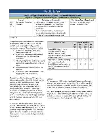
Project Performance Measure(s) City Service Team (Department)
Core Stormwater Education Participate in FEMA’s Community Rating Economic Development and
PS Outreach System and achieve a 5 rating by 2020 Capital Investment (PWT)
2.2.2 Number of public education campaigns
conducted
Number of stormwater pollution safety
presentations given at elementary schools
Number of community events attended
Summary:
Comprehensive watershed studies are important Outreach Task Number Achieved
to evaluate current and future flood risk and
rd
st
nd
th
1 2 3 4
identify problem areas that will guide the
Qtr. Qtr. Qtr. Qtr.
stormwater program. These watershed studies:
Update the hydrology for current Attend 10 Children’s Events 4 7 0 0
targeting ages 12 & under.
developed conditions
Update the hydraulic models based on (Includes schools, library
programs, after school programs,
the new flows and current creek
summer camps, etc.)
conditions
Identify and prioritize problem areas and Placement of 350 “No Dumping” 97 150 96 85
storm drain inlet decals
generate conceptual solutions for these Attend 10 community events to 4 3 0 0
areas
Assess the stream bank conditions for provide stormwater education
materials
erosion
Update the Flood Insurance Rate Maps
based on the new information
This data benefits the citizens of Arlington by Update:
informing them of the flood risk for their homes, Per our adopted PPI Plan, the Floodplain Management Program
so they can take protective action. It also implemented new outreach material, the Mayor’s Postcard. This
identifies flood protection projects to be postcard has been sent to residents and business owners in flood
incorporated into the Stormwater Capital prone areas not included in FEMA’s delineated floodplain.
Improvement Plan. Arlington's nine major
watersheds have been grouped into six major The City of Arlington completed its initial FEMA audit for the CRS
study areas. The Stormwater Division plans to
Program. The Floodplain Management Group is coordinating and
include watershed studies in its budget each year providing comments as required. Once completed, the City will
until all the major watersheds in the City have receive its updated Class Rating in the CRS Program.
been studied.
This project will identify and map flood risk for
property owners which enhances the City’s score
in the Community Rating System (CRS). The CRS is
a federal program that provides flood insurance
policy discounts based on community score for
homeowners in communities that participate in
the program.
128