
Page 476 - Microsoft Word - FY 2020 Adopted Budget Document
P. 476
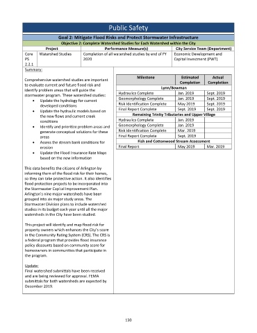
Public Safety
Goal 2: Mitigate Flood Risks and Protect Stormwater Infrastructure
Objective 2: Complete Watershed Studies for Each Watershed within the City
Project Performance Measure(s) City Service Team (Department)
Core Watershed Studies Completion of all watershed studies by end of FY Economic Development and
PS 2020 Capital Investment (PWT)
2.2.1
Summary:
Milestone Estimated Actual
Comprehensive watershed studies are important
Completion Completion
to evaluate current and future flood risk and Lynn/Bowman
identify problem areas that will guide the
stormwater program. These watershed studies: Hydraulics Complete Jan. 2019 Sept. 2019
Update the hydrology for current Geomorphology Complete Jan. 2019 Sept. 2019
Risk Identification Complete May 2019 Sept. 2019
developed conditions
Update the hydraulic models based on Final Report Complete Sept. 2019 Sept. 2019
the new flows and current creek Remaining Trinity Tributaries and Upper Village
conditions Hydraulics Complete Jan. 2019
Identify and prioritize problem areas and Geomorphology Complete Jan. 2019
generate conceptual solutions for these Risk Identification Complete Mar. 2019
areas Final Report Complete Sept. 2019
Assess the stream bank conditions for Fish and Cottonwood Stream Assessment
erosion Final Report May 2019 Mar. 2019
Update the Flood Insurance Rate Maps
based on the new information
This data benefits the citizens of Arlington by
informing them of the flood risk for their homes,
so they can take protective action. It also identifies
flood protection projects to be incorporated into
the Stormwater Capital Improvement Plan.
Arlington's nine major watersheds have been
grouped into six major study areas. The
Stormwater Division plans to include watershed
studies in its budget each year until all the major
watersheds in the City have been studied.
This project will identify and map flood risk for
property owners which enhances the City’s score
in the Community Rating System (CRS). The CRS is
a federal program that provides flood insurance
policy discounts based on community score for
homeowners in communities that participate in
the program.
Update:
Final watershed submittals have been received
and are being reviewed for approval. FEMA
submittals for both watersheds are expected by
December 2019.
130