


Page 109 - CityofSouthlakeFY27Budget
P. 109
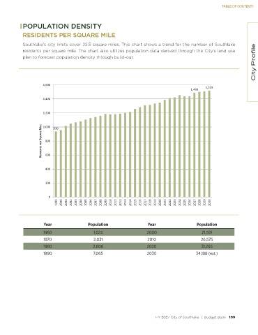
TABLE OF CONTENTS


            POPULATION DENSITY
            RESIDENTS PER SQUARE MILE

            Southlake’s city limits cover 22.5 square miles. This chart shows a trend for the number of Southlake
                                                                                                                          City Profile
            residents per square mile. The chart also utilizes population data derived through the City’s land use
            plan to forecast population density through build-out.


                     ϭ͕ϲϬϬ
                                                                                            ϭ͕ϰϵϬ  ϭ͕ϱϭϵ
                     ϭ͕ϰϬϬ


                     ϭ͕ϮϬϬ


                     Z ^/  Ed^ W Z ^Yh Z  D/>   ϴϬϬ  ϵϯϲ
                     ϭ͕ϬϬϬ


                       ϲϬϬ


                       ϰϬϬ


                       ϮϬϬ


                        Ϭ
                            ϭϵϵϵ  ϮϬϬϬ  ϮϬϬϭ  ϮϬϬϮ  ϮϬϬϯ  ϮϬϬϰ  ϮϬϬϱ  ϮϬϬϲ  ϮϬϬϳ  ϮϬϬϴ  ϮϬϬϵ  ϮϬϭϬ  ϮϬϭϭ  ϮϬϭϮ  ϮϬϭϯ  ϮϬϭϰ  ϮϬϭϱ  ϮϬϭϲ  ϮϬϭϳ  ϮϬϭϴ  ϮϬϭϵ  ϮϬϮϬ  ϮϬϮϭ  ϮϬϮϮ  ϮϬϮϯ  ϮϬϮϰ  ϮϬϮϱ  ϮϬϮϲ  ϮϬϮϳ  ϮϬϮϴ  ϮϬϮϵ  ϮϬϯϬ


                      Year                 Population                  Year                   Population
                      1960                   1,023                     2000                      21,519
                      1970                   2,031                     2010                     26,575
                      1980                   2,808                     2020                      31,265
                      1990                   7,065                     2030                   34,188 (est.)


                                                                           FY 2027 City of Southlake  |  Budget Book   109

